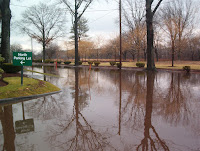
Climate change is creating more rainfall and higher sea levels. These trends will both contribute to more flooding in our neighborhoods.
The National Oceanic and Atmospheric Administration estimated in 2012 that, on average, worldwide, sea levels will rise between 8 inches and 6.6 feet by 2100 — that’s the 90% confidence interval. Some recent findings suggest that sea levels may rise faster than projected.
Communities along the Charles and Mystic Rivers — Back Bay, Fenway, Allston, Cambridge, Watertown, Belmont — are protected by seawalls at the mouths of those two rivers. The Amelia Earhart dam and the Charles River dam keep river levels down by closing to keep the high tides out and then opening at low tide to allow the rivers to drop. They are equipped with massive pumps capable of driving the full flood flow of the rivers out even at high tide.
Over the last few years, a lot of work has been done by state and local agencies to understand how the major dams will perform as waters rise higher. The City of Cambridge recently rolled out the results of their very thorough analysis of the question. They concluded that the larger storms (1% chance or “100- year” storms) will start to flank and/or overtop both dams around the middle of this century, at least in the higher sea-level rise scenarios. It appears that the dams offer effective protection until at least 2030.
It’s important to understand that even when water gets past the dams the neighborhoods behind the dams will not be completely inundated — sea water will flow over or around the dams at a finite rate of speed and, when the tide goes out will subside, even if the storm continues.
Cambridge’s work suggests that the flood risks associated with increased precipitation are actually greater than the flood risks from sea-level rise (for communities along the rivers). When heavy rain falls accumulate in the river systems, the waters rise and may peak a day or two after the actual rain event. Low lying parts of North Cambridge, East Arlington and Belmont may be exposed to flood waters over 3 feet in depth in the 100 year storms by late in the century. The low-side of Back Bay (close to the river along Beacon Street) and some neighborhoods in Allston are also likely to experience new risks of inundation.
Read more at Planning for More Flooding

No comments:
Post a Comment