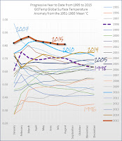
NASA reports that this was the hottest start to any year on record by far. This was the hottest August by far in the dataset of the Japan Meteorological Agency, and close to tied with 2014 for hottest August in the NASA dataset.
With the underlying long-term warming trend adding to the short-term warming from the strongest El Niño since the big one of 1997-1998, you can bet the house that this will be the hottest year on record by far.
Different climate-tracking groups around the world use different data sets, so they can show different results for a given month. The Japan Meteorological Agency is a World Meteorological Organization Regional Climate Center of excellence.
Here is the horserace chart — the running year-to-date average temperature — for the past two decades, from HotWhopper.
The datapoint for January of each year just shows the anomaly (temperature above the 1951-1980 mean) for January of that year. “For February it shows the average of January and February for each year,” HotWhopper reported. “For March, it’s the average of the monthly anomaly from January to March.” And so on until December, which is the “annual average temperature for the full year.”
As the chart shows, 2015 has set a pace the other years can’t keep up with. In all likelihood, 2015 warming will increase over the coming months due to the increasing temperatures in the east-central tropical Pacific associated with the current El Niño, as I discussed in my Saturday post. And that means 2016 could well top 2015.
Indeed, the U.K. Met Office reports that broader trends in the oceans “are consistent with a return of rapid warming in the near term.” The long-awaited speed up in global temperatures is here.
Read more at Hot August Confirms that Long-Awaited Global Temperature Speed Up Is Here


No comments:
Post a Comment