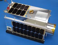
Group backed by Canada's government and major oil producers hopes GHGSat more accurately reads methane and carbon emissions in Alberta and beyond.
A $10 million dollar satellite will be launched next week to attempt to do something that has proved so elusive from the ground: comprehensively measuring the carbon dioxide and methane emissions billowing from Alberta's sprawling tar sands operations, and eventually fossil fuel operations anywhere.
The satellite, built by the Montreal-based GHGSat, is funded by a group including major oil sands producers and the Canadian government and will blast off into space from the Satish Dhawan Space Centre in India on June 21. The hope is that, once in place 318 miles above Earth, the satellite will produce measurements with a resolution 400 times finer than current satellites produce.
While everyone agrees on the need for better measurements, nobody knows if the satellite can produce them.
Most of the scientists contacted by InsideClimate News questioned whether the company would succeed because satellite technology hasn't evolved enough to map emissions from specific sources, and its modeling would be too difficult to substantiate.
"There's a healthy degree of skepticism out there that we're going to do this. I hope we're going to be able to prove to them that we can," said Stephane Germain, a physics engineer and the president of GHGSat.
Zeroing in on individual emissions sources is tricky. The satellite will have to measure a concentration of methane from space and then somehow track those molecules back to a single source. It's extremely difficult to account for wind and other emissions that could enter into the observed area.
Initially, the satellite will attempt to pinpoint methane and CO2 leak rates at two tailings ponds that store oily waste and one mine. If successful, the oil sands industry contends the method could become the new industry standard for measuring emissions from all tar sands operations. The larger goal is to become the global standard for tracking emissions as the need for better data increases after the Paris climate agreement.
Methane, a potent greenhouse gas, has been the most elusive to understand. The difficulty in gathering data stems from both technological and logistical shortcomings: Ground measurements are costly and time-consuming, and private firms can deny access to regulators and scientists. And current measurements from satellite and aircraft are too imprecise or do not provide the necessary around-the-clock coverage to gauge emissions from individual sources and identify major leaks. The result is data that vastly underestimates the methane problem.
The launch comes just as Alberta readies its first crackdown on emissions from the oil industry. Even more stringent new reporting standards could be in the works as part of Alberta's sweeping climate change strategy. Alberta's new premier, Rachel Notley of the New Democratic Party, has pledged to cap oil sands emissions for the first time—at 100 million metric tons, compared with current production levels of around 70 million metric tons—while also imposing a $30 per ton carbon price. Her government also promised to work with industry to slash methane emissions 45 percent lower than projected 2020 levels by 2025.
Four of the biggest oil sands producers—ExxonMobil subsidiary Imperial Oil, Shell, Canadian Natural Resources Limited, and Suncor Energy—are behind the project and part of the 13-member Canada Oil Sands Innovation Alliance (COSIA) that focuses on bringing environmental technologies to market. Other GHGSat partners include Boeing, which provided the systems engineering and advised on the space vehicle design, Hydro-Quebec, and LOOK North, a remote sensing company.
If companies are serious about cutting methane pollution, then satellite monitoring makes economic sense, according to Robert Jackson, an earth systems science professor at Stanford University.
"To check facilities now, they send one or two people in a pickup truck, and they drive from well pad to well pad. That's time-consuming and expensive," he said. "I think the satellites are particularly useful for companies because they will help people find the big leaks."
'The Curse of Remote Sensing'
Measuring greenhouse gas emissions from space isn't new. But GHGSat is attempting to assess emissions with more clarity than any other space endeavor to date.
Most satellite technologies look at a 1-kilometer-square field. The GHGSat will be more exact because it will focus on a 2,500-square-meter resolution. GHGSat will use its own low-power, lightweight imaging spectrometer—to better pinpoint emission sources in a large atmospheric column—and what's called "inverse dispersion modeling" to track the methane concentration in a specific plume back to the source of emissions.
Jackson said he's "more skeptical" of the company's ability to accurately model the source of the methane than the technology's basic ability to map methane at a higher resolution.
Read more at Oil Industry Satellite for Measuring Climate Pollution Set to Launch

No comments:
Post a Comment