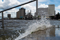
With climate change loading the dice for disaster, a storm fueled by warmer-than-normal Gulf water is headed for a Mississippi River already swollen with floodwater.
The Gulf Coast is about to be pummeled by a three-punch combo: Flooding from heavy rains over the winter and spring has been sending record floodwaters coursing down the Mississippi River, pushing the river close to the top of its protective levees in Louisiana. Now a cyclone fueled by warm offshore waters is threatening downpours in the same area and a storm surge up the bayous at the river's mouth.
Louisiana Gov. John Bel Edwards warned residents this week to be prepared for flooding from two sides—both the Gulf of Mexico and the Mississippi River.
It's the kind of compounding of risks that scientists have been warning about as the climate changes. Climate change has loaded the dice for this kind of coincidence, scientists say.
It was the water, rather than the wind, that was causing the most intense concern as Tropical Storm Barry gained strength and disaster declarations and evacuations began.
Like Hurricane Florence in North Carolina last year and the remnants of Hurricane Harvey, which sat over Houston for days in 2017, Barry was moving slowly, creating a threat of days of heavy rainfall and flooding on the coast and lower Mississippi Valley, the National Hurricane Center wrote on Friday.
In Louisiana's rivers, with water levels already high, Barry's expected storm surge of 3 feet or more would push the water even higher.
Read more at Flood Risks from All Sides: Barry's Triple Whammy in Louisiana

No comments:
Post a Comment