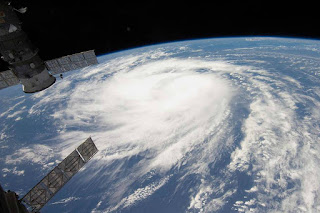
A spate of record-breaking storms has spurred a call for expanding the hurricane scale for better warnings that could save lives.
As the 2018 Atlantic hurricane season begins, scientists are worried that U.S. coastal communities could face more super storms with winds, storm surges, and rainfall so intense that current warning categories don't fully capture the threat.
This year's forecast is about average and much more subdued than last summer's hyperactive season turned out to be, partly due to cooler ocean temperatures in the tropical Atlantic, as well as a nascent El Niño pattern. But that doesn't mean an individual storm won't blow up to exceptional strength, as Andrew did before striking Florida in 1992, an otherwise relatively quiet year.
Heat trapped by the increasing concentration of greenhouse gases in the atmosphere is raising the chances of that happening, said Penn State climate scientist Michael Mann.
A new review of global data on hurricanes shows that since 1980, the number of storms with winds stronger than 200 kilometers per hour (124 mph, or a strong Category 3) have doubled, and those with winds stronger than 250 kilometers per hour (155 mph) have tripled.
The analysis, published this week by four prominent climate scientists, also shows other clear trends, including a poleward migration of the areas where storms reach peak intensity, which puts new areas at risk, including New England and even Europe.
Storms are also intensifying more quickly, with a greater chance they will drop record amounts of rain, especially if they stall out when they hit land, as Hurricane Harvey did in Houston last year.
"The weight of the evidence suggests that the 30-year-old prediction of more intense and wetter tropical cyclones is coming to pass. This is a risk that we can no longer afford to ignore," wrote the authors—Stefan Rahmstorf of the Potsdam Institute for Climate Impact Research, Kerry Emanuel of MIT, Jim Kossin of NOAA, and Mann.
Mann advocates for adding a new Category 6 to the Saffir-Simpson Hurricane Wind Scale to describe the extremely powerful super storms seen in recent years—storms that can be fueled by global warming.
"The current intensity scale doesn't capture the fact that a 10 mph increase in sustained wind speeds ups the damage potential by 20 percent," Mann said. "That's not a subtle effect. It's one that we can see." Based on the spacing of Categories 1-5, there should be a Category 6 approaching peak winds of 190 mph, he said.
Creating a new warning level for unprecedented storms could help save lives. When Typhoon Haiyan, one of the strongest tropical cyclones on record, hit the Philippines in 2013, people died in shelters that had been designed to withstand a historic storm surge but still flooded.
Read more at Hurricane Season 2018: Experts Warn of Super Storms, Call For New Category 6

No comments:
Post a Comment