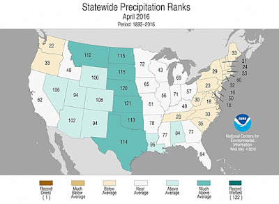
Although the warmth was notched down a bit from the year’s first quarter, April was still much milder and moister than average, according to the monthly U.S. climate roundup released on Wednesday by the National Centers for Environmental Information. The monthly average for the contiguous 48 states came in at 53.2°F, which is 2.2°F above the 20th-century average and the 18th warmest among the 122 Aprils since records began in 1895. Outside of New England, New York, Pennsylvania, and Michigan, every state came in above its long-term average (see Figure 1), and it was a top-five warmest April for Idaho, Oregon, and Washington. The only place that saw record statewide warmth in April was Alaska, which merits a separate discussion (see below).
There were plenty of April showers this year, especially across the Great Basin and Great Plains. The month came in as the 21st wettest on record for the 48 contiguous states, with a 48-state reading of 2.95” (0.43” above the 20th-century average). It was a top-ten wettest April for the entire Plains corridor from Texas to North Dakota (Figure 2). The apex of last month’s precipitation was the phenomenally heavy rain and severe flash flooding in Houston on April 18. More than than a foot of rain fell in northwest parts of the Houston area, and the city officially saw its second wettest day on record (9.92”, topped only by 10.34” during Houston’s “first” Tropical Storm Allison in 1989). Across the southwest U.S., where moisture was scant earlier this year despite the strong El Niño, generous precipitation finally arrived.
Daily record highs are far outpacing record lows this year
It’s no longer quite the warmest year on record for the United States thus far (although the planet is still demolishing year-to-date records--stay tuned for our global roundup next week). The average temperature for the contiguous U.S. (January-April 2016) now ranks second behind only 2012. The tally of daily record highs and lows across the nation reinforces this warm picture: as of Wednesday morning, the year-to-date tallies on NOAA’s Daily Weather Records site show a total of 10,328 record daily highs and just 1286 record lows, a ratio of just over 8:1. Last year’s ratio ended up close to 3:1, after two oddly chill years in which the nation saw more daily record lows than highs (no such years had occurred since 1993).
Read more at April Keeps the Warm, Wet U.S. Trend Going for 2016


No comments:
Post a Comment